48 Hours in Big Sur
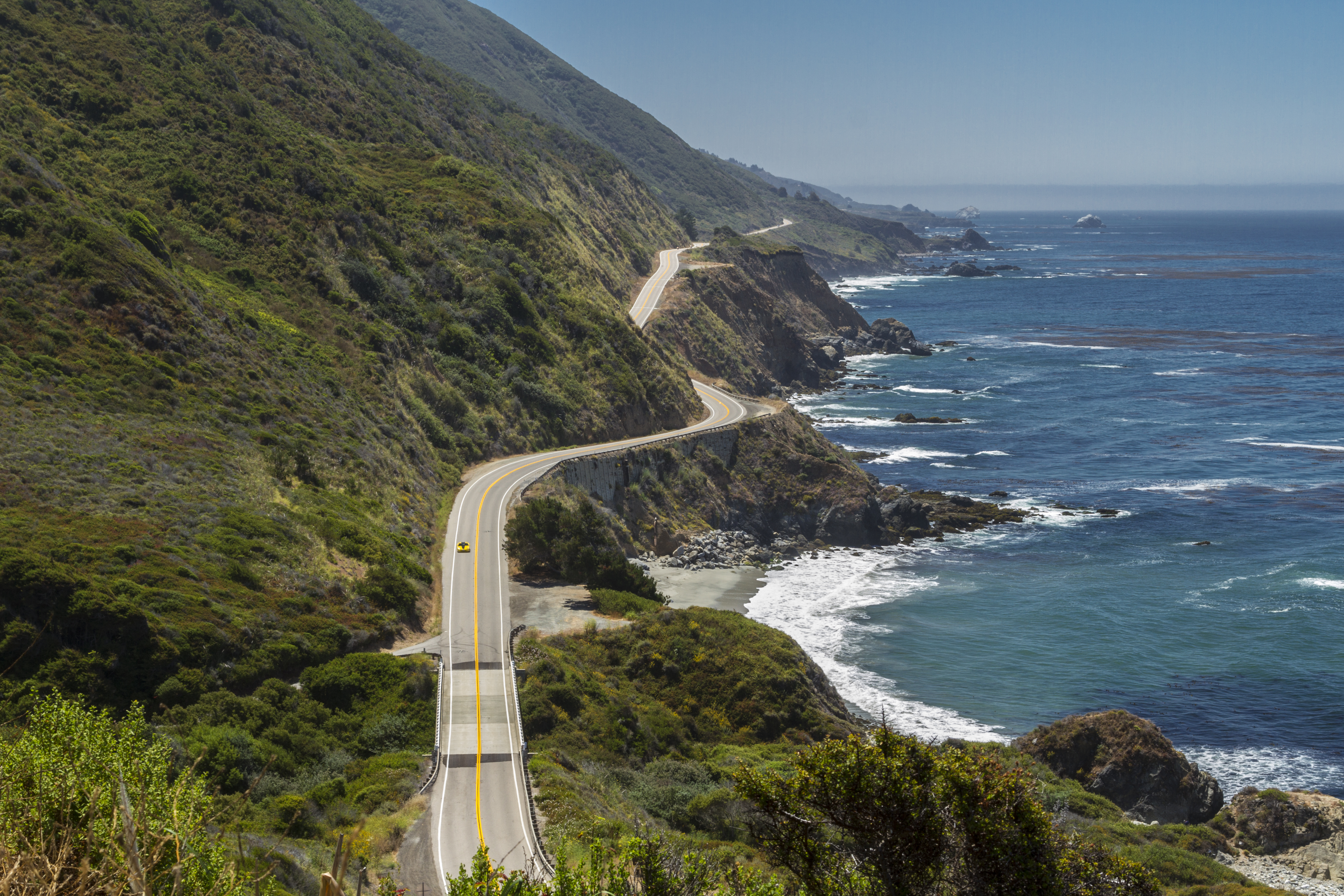
Two days of cliffs, redwoods, Highway 1, and the rare California landscape that makes getting somewhere less important than the road between.
Big Sur isn't really a town.
It isn't a single park either.
It's a stretch of California coast where the Santa Lucia Mountains rise abruptly beside the Pacific and Highway 1 finds its way between them.
That's important because Big Sur requires a different kind of 48-hour trip.
There isn't a downtown where we'll park the car and spend the afternoon wandering between shops and restaurants.
There isn't one attraction we're trying to reach.
Here, the road is part of the destination.
You'll round a curve and see the Pacific hundreds of feet below.
Ten minutes later, you may be surrounded by redwoods beside the Big Sur River.
Another bend reveals cliffs, another bridge, another canyon, another stretch of coastline disappearing into the distance.
The temptation is to stop at every turnout.
Don't.
Big Sur becomes surprisingly exhausting when every beautiful view becomes another appointment.
We're going to choose carefully.
Big Sur isn't a collection of stops along Highway 1. Highway 1 through Big Sur is the experience connecting them.
At a Glance
Best for: Couples, photographers, hikers, nature lovers, road-trip travelers, and anyone who occasionally wants scenery to be the entertainment.
The pace: Slow and deliberately flexible.
Stay: Two nights.
Don't miss: Highway 1 itself, Bixby Creek Bridge, the redwood and river landscape, the central Big Sur coastline, and at least one moment when you simply stop somewhere beautiful.
Good to know: Highway conditions, park access, trails, wildfire impacts, weather, and coastal conditions can change. Big Sur is one destination where checking conditions shortly before departure is essential.
Where to Stay
If your budget and availability allow it, stay in Big Sur itself.
There are campgrounds, cabins, inns, lodges, and some exceptionally expensive resorts.
The particular property matters less to our itinerary than its location.
Staying within Big Sur lets you experience the area before and after many day visitors have left.
It also means you don't spend the beginning and end of each day commuting from Monterey or somewhere farther north.
That matters here.
An evening when you no longer need to drive Highway 1 is part of the experience.
Big Sur lodging can fill well ahead of time, particularly during popular travel periods, so this isn't a destination where I'd depend on finding something after arriving.
Reserve the room.
Then build the trip around it.
Day 1 — Enter Big Sur Slowly
Approach from the north.
As you leave the Carmel area behind, watch the landscape change.
Development begins thinning.
The mountains move closer.
Highway 1 begins clinging more tightly to the coastline.
And eventually you'll realize that getting somewhere has stopped being the most interesting part of the drive.
That's Big Sur announcing itself.
Bixby Creek Bridge
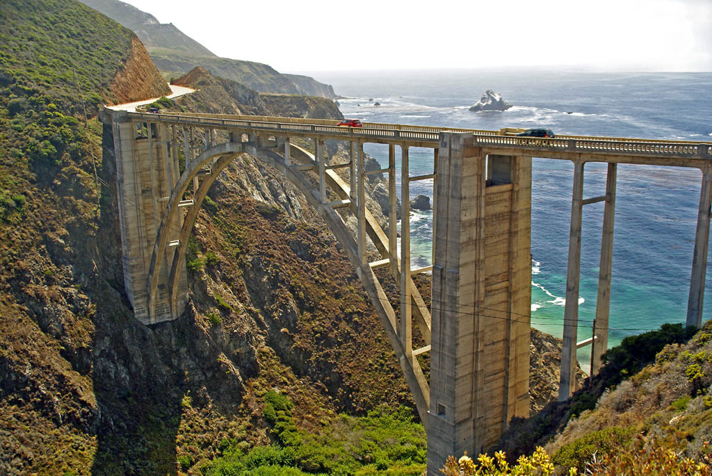
Make Bixby Creek Bridge one of your first deliberate stops.
It's one of California's most recognizable bridges for good reason.
But this doesn't need to become a lengthy attraction.
Find a safe, legal place to stop.
Walk to an appropriate viewpoint.
Look at the bridge, the canyon, the cliffs, and the Pacific.
Take the photograph.
Then put the camera down for a minute.
Look again.
And continue south.
Don't Stop Everywhere
This may be the most useful advice in our entire Big Sur itinerary.
There will be another turnout.
There will be another cliff.
There will be another extraordinary ocean view.
You don't need all of them.
Choose some.
Pass others.
If a particular place makes you want to stop, stop.
But don't allow every turnout to become an obligation simply because someone marked it on a map.
We're not collecting viewpoints.
We're traveling through a landscape.
Afternoon — From Cliffs to Redwoods
Continue into the Big Sur River corridor.
This is one of the transitions that makes Big Sur particularly memorable.
The exposed coastal landscape begins giving way to trees, river country, and redwoods.
Under normal operating conditions, Pfeiffer Big Sur State Park is one of the places where visitors can experience this inland side of Big Sur.
The park lies along the Big Sur River on the western slope of the Santa Lucia Mountains and is known for its redwood environment and trails.
An important distinction:
Pfeiffer Big Sur State Park is not an oceanfront park.
That's precisely why it belongs in our itinerary.
We've spent much of the day looking at the Pacific.
Now Big Sur shows us something else.
Choose a walk or trail appropriate to current conditions, available time, and your ability.
We aren't prescribing one mandatory hike because trail access can change.
If a short walk beneath the trees is enough, let it be enough.
Late Afternoon — Check In
Now stop traveling.
Check into your lodging.
Unload the car.
Sit somewhere.
Walk around the property.
Listen.
Big Sur gets quieter after the day's traffic begins thinning.
Give yourself an opportunity to notice.
Evening — Stay Nearby
Have dinner at your lodging or somewhere reasonably close.
Don't spend the evening driving thirty miles because a restaurant farther down Highway 1 has better online reviews.
Darkness changes Highway 1.
So do fog and weather.
And you already spent much of the day on the road.
Tonight we're staying close.
If there's somewhere outside to sit safely afterward, do that.
Big Sur doesn't need much help entertaining you.
Day 2 — Follow Highway 1 South
Start relatively early.
Today we're going deeper into the Big Sur coastline.
But again, we aren't measuring success by mileage.
The objective isn't to drive as far south as possible.
The objective is to experience the coast.
Morning — Julia Pfeiffer Burns and McWay Falls
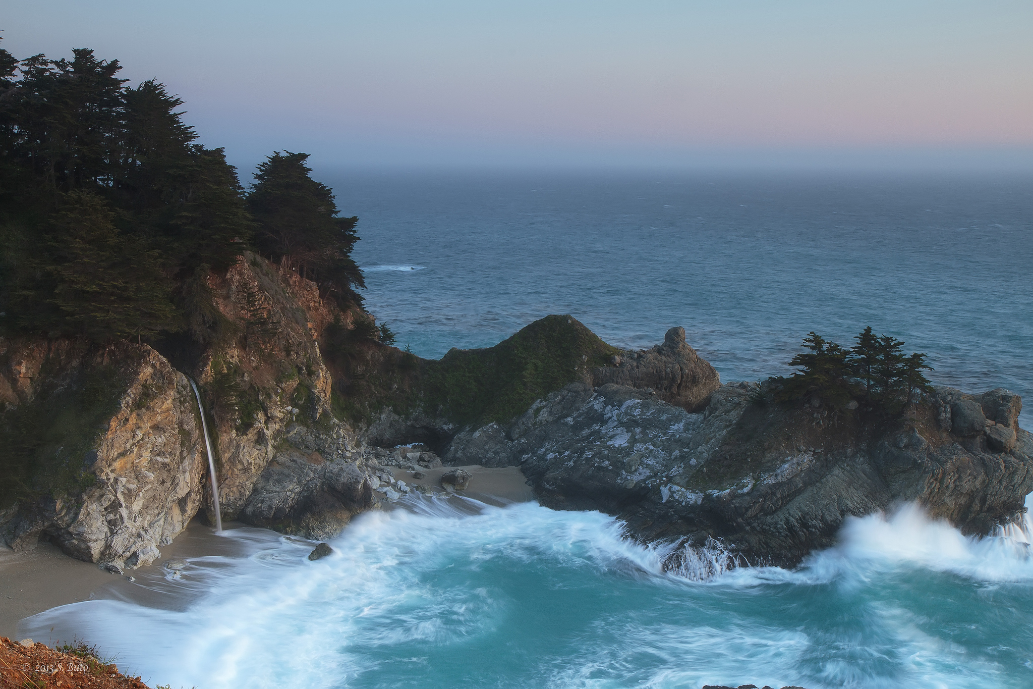
Under normal access conditions, make Julia Pfeiffer Burns State Park one of the day's principal stops.
This is home to McWay Falls, where water drops from the cliffs toward the protected cove below.
View it from the designated trail and overlook areas that are open during your visit.
Do not attempt to reach the beach.
There is no public beach access at McWay Falls, and closed areas beyond barriers exist for safety and resource protection.
This gives us an important Big Sur rule:
A beautiful photograph isn't permission to ignore a boundary.
Big Sur contains steep cliffs, unstable terrain, powerful surf, protected habitat, and changing conditions.
Respecting barriers isn't interfering with the experience.
It's part of experiencing this landscape responsibly.
Continue South — But Not Automatically
After McWay Falls, continue south if current Highway 1 conditions, weather, and your own interest make sense.
Stop selectively.
Maybe there's a viewpoint that catches your attention.
Maybe current park conditions give you an opportunity for another coastal walk.
Maybe you've already seen enough from the car and would rather spend more time in one place.
All are legitimate choices.
This is where we're intentionally leaving space in the itinerary.
Big Sur changes.
Road conditions change.
Trail conditions change.
Weather changes.
Your energy changes.
The itinerary needs to accommodate all four.
Choose One Walk
If you want more hiking today, choose one trail based on current conditions.
Don't arrive committed to a particular hike you read about six months earlier.
Check what's open.
Consider the weather.
Consider how much daylight remains.
And consider whether you actually want a substantial hike or simply another hour outside.
The longest trail isn't automatically the best experience.
Sometimes a short coastal walk followed by an hour looking at the Pacific is exactly right.
Lunch — Keep It Simple
Have lunch somewhere convenient to your route, or carry what you need if that's appropriate for your plans.
Big Sur isn't the place to build the day around driving to a specific restaurant at a specific minute.
Food matters.
But flexibility matters more.
And carry water.
Afternoon — Turn Around
At some point, turn north.
That may sound anticlimactic.
It isn't.
One of the pleasures of Highway 1 is discovering that driving the same stretch in the opposite direction doesn't necessarily feel like repeating it.
The perspective changes.
The light changes.
The coastline unfolds differently.
And the Pacific now appears from another angle.
Remember some of those turnouts you passed this morning?
Now you can choose one.
Stop.
Take your time.
Then continue north.
Late Afternoon — Stop Driving
Return to your lodging area early enough that the day doesn't end with you arriving exhausted after dark.
This afternoon deliberately has no major attraction.
Sit near the river.
Return to the redwoods.
Have coffee.
Read.
Walk.
Take a nap.
Find somewhere safe to watch the light change.
The freedom to stop moving is one of the reasons we stayed in Big Sur rather than simply driving through it.
By now, the road that seemed dramatic and unfamiliar when you arrived has begun acquiring landmarks.
Big Sur has started becoming a place rather than simply a scenic highway.
Evening — One More Big Sur Night
Have dinner.
Talk about the places that surprised you.
Maybe it was McWay Falls.
Maybe Bixby Bridge.
Maybe a redwood.
Maybe it was an unnamed turnout where you spent twenty minutes watching waves hit the cliffs.
That last possibility is exactly why we've resisted overplanning this trip.
Tomorrow morning, don't rush out.
Have breakfast.
Walk outside.
Look at the trees or mountains or Pacific—whatever your lodging gives you.
Then begin the drive home or toward your next California destination.
Unless you have another three hours.
If You Have 3 More Hours
Point Sur
Consider Point Sur State Historic Park.
The dramatic volcanic rock rising beside Highway 1 is difficult to miss, but the historic lighthouse above it provides a completely different experience from our other Big Sur stops.
Access is generally through scheduled guided tours rather than simply wandering onto the property, so this extension requires more planning than one of our scenic overlooks.
Check the current tour schedule before building it into your trip.
If the timing works, it adds history, maritime life, and a human story to a weekend dominated by landscape.
If it doesn't work, don't force it.
Big Sur has already given you plenty.
If You Have One More Day
Point Lobos and the Transition Toward Carmel
Head north toward Point Lobos State Natural Reserve.
Point Lobos deserves more time than we wanted to steal from our core Big Sur itinerary.
Its headlands, coves, coastal trails, wildlife, and views provide a wonderful transition between Big Sur's dramatic coastline and Carmel-by-the-Sea.
Spend several hours walking rather than racing through.
Then continue toward Carmel.
This also illustrates something important about our growing 48 Hours in California collection:
Destinations don't always end at a municipal boundary.
Sometimes one landscape gradually introduces the next.
Big Sur leads naturally toward Carmel and Monterey.
We'll let those places tell their own stories.
Before You Go
Big Sur requires more preparation than many of our other 48-hour destinations.
First, check Highway 1 conditions shortly before departure.
Not only when you book the trip.
Not only a week beforehand.
Check again before you leave.
Road work, slides, fires, weather, and other events can change access and travel times.
Check current California State Parks conditions too.
A trail or park area that was open when this guide was written may not be open when you arrive.
Download offline maps.
Cell service can be extremely limited or nonexistent in portions of Big Sur.
Don't depend on your phone suddenly finding a signal when you need directions.
Fuel the car before entering the more remote portions of the coast.
Don't make searching for gasoline part of the adventure.
Carry water.
Bring food or snacks appropriate to your plans.
Wear shoes suitable for the walks you intend to take.
Bring layers.
Coastal weather can change quickly.
And avoid building a schedule so precise that a twenty-minute delay ruins the afternoon.
Big Sur doesn't operate according to your itinerary.
Fog arrives.
Road work happens.
Parking fills.
A trail closes.
Or perhaps you find a viewpoint so beautiful that you decide to stay there much longer than expected.
That last one isn't a problem.
It's the reason you came.
Most importantly, drive carefully.
Highway 1 demands attention.
If you want to admire the scenery, use a safe, legal turnout and stop the car.
The person driving shouldn't be trying to experience Big Sur through the side window.
And when you do stop, don't feel compelled to photograph everything.
Some landscapes are allowed to exist without becoming content.
Big Sur isn't a collection of stops along Highway 1. Highway 1 through Big Sur is the experience connecting them.
And remember what these trips are supposed to be:
48 hours away—not 48 hours of appointments.
Related Getaways
Continue north with 48 Hours in Carmel-by-the-Sea, where Big Sur's wild coastline gives way to a walkable village, distinctive architecture, restaurants, beaches, and another very different relationship with the Pacific.
Nearby 48 Hours in Monterey adds California history, Cannery Row, Monterey Bay, marine life, and one of the state's most recognizable coastal communities.
Farther south, 48 Hours in Cambria continues the Highway 1 story with a smaller coastal town, Moonstone Beach, and a much gentler pace.
And farther inland, 48 Hours in Paso Robles exchanges ocean cliffs for vineyards, ranchland, and wine-country roads.
Big Sur is different from all of them.
There isn't much of a town to explore.
There isn't a long restaurant list to complete.
There isn't even one attraction that explains why people come.
The explanation is outside the windshield.
Mountains.
Redwoods.
Cliffs.
Ocean.
Highway.
And enough empty space between them to remind us that sometimes the best part of traveling somewhere is simply being on the way.
Photo Credits
Highway 1, Big Sur: Fred Moore, via Wikimedia Commons/Flickr, licensed under CC BY 2.0. Image cropped for display.
Bixby Creek Bridge: Rod Jones Photography (Astronautilus), via Wikimedia Commons/Flickr, licensed under CC BY 2.0. Image cropped for display.
McWay Falls: Sue B., via U.S. Geological Survey/Wikimedia Commons/Flickr, licensed under CC BY 2.0. Image cropped for display.